Sunday, July 31, 2011

GREEN MOUNTAIN TRAIN WRECK, MARCH 21, 1910, 8:14 AM

The Search
Not much left in Green Mountain after the storm that went thru here a couple of weeks ago. Of course, I don’t know if there was much left to Green Mountain BEFORE the storm hit, but the devastation to grain storage areas, buildings and barns, and trees it horrible.

Driving thru town, the smell of burning wood and debris is everywhere. People are still trying to pick up the pieces and put it back together again.


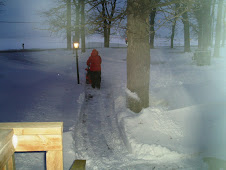
Green Mountain ‘town square” is a windmill and water pump in the middle of the street with a little park bench that says “Welcome.” And what is more welcoming than fresh cold well water and a bench to rest on on a hot Iowa summer day.

Checked with a couple of people in town as to the location for a marker for the train wreck. “Nope! Nothin’ like that around here.” Oh, don’t tell me that – that sounds like a challenge to me.


According to what I’d been reading, the wreck happened between Gladbrook and Green Mountain, east of the Marshall County/Tama County line. It’s only 12 miles between Green Mountain and Gladbrook. How difficult can it be to find the spot – even if the train tracks are no longer there – “4 ½ miles north of Green Mountain, just a few yard east of the Marshall-Tama county line,” said the Marshalltown Times-Republican of that date.

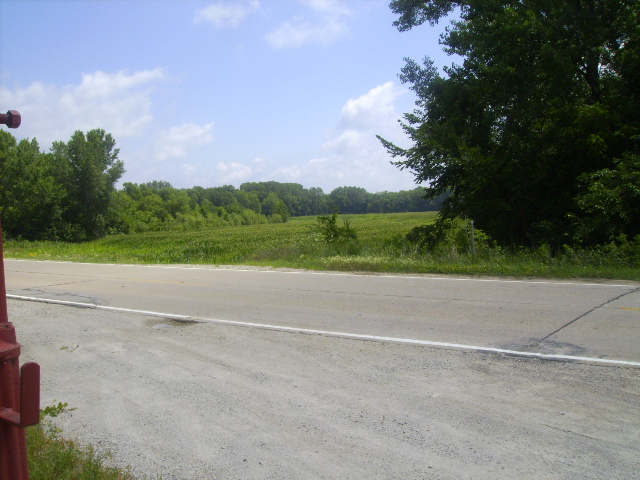
With my trusty MapQuest and Google maps in hand, I proceeded up and down some of Iowa’s finest dusty rural graded gravel roads. And by the clouds of dust whirling behind me, I don’t believe we have had one drop of rain here – and I know better! Up one road, down the next. I do appreciate the fact that most of Iowa’s country roads are parallel and perpendicular to each other. Makes it much easier to back-track when I don’t have to worry about which fork in the road to take! Trying to keep water towers in view (so I don’t get too lost), I continue stirring up dust. Making the adventure somewhat difficult is the fact that the gravel roads have names (probably of the farmer that lives on the road!) and my maps have the roads identified with the E-911 geo-code numbers.

Nothing – head up to Gladbrook. Stopped in the convenient store and asked about the train wreck. “There’s no marker but we do have a museum, you can call and make an appointment, they have lots of stuff from the wreck.” (Note to self: Call Gladbrook Museum next week if all else fails.)

If there is no marker in Green Mountain, none in Gladbrook, I’ll just wander on back around the county roads and see if I can find the ‘likely spot’ of the accident.

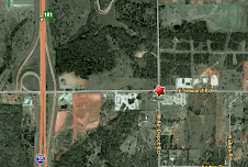
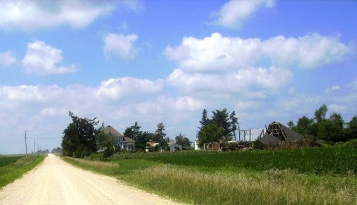
Heading west out of Gladbrook, I notice a long diagonal line of utility poles – bet they follow the old train bed! Keeping an eye on them, I watch for the Tama-Marshall county line marker on the highway. BINGO! There it is between Abbott Road and Zeller Road and I remember both of those coming out near Green Mountain. Whip a U-turn and head down Abbott Road, that seems like the best bet since the accident was “a few yards east” of the line.

And there it is – the spot where the utility lines cross Abbott Road. Stop and take a picture. Consider the adventure a success and head on back to civilization (less dust and paved roads!)

Heading south on Abbot, less than ¼ mile from where I stopped to get a picture of the lines crossing the road – a spot of mown green grass, a rock, a little flag and a couple of ‘everlasting’ plastic flower bouquets. That’s it. My Gold Mine for the Day!

I left my bouquet of daisies for Bruce’s cousin who was killed in the wreck, leaned back against the truck for a few moments and tried to imagine the carnage, the confusion of that day. Knowing the distance from Marshalltown I had traveled, imagining what it must have been like to travel it with horse and wagon or in the few automobiles available at the time, not knowing what I would find at the end.
What they found at the end was the remains of the Rock Island Nos. 19 and 21 trains reduced to piles of torn metal, wooden kindling and shattered glass along with scores of wounded and dead, bodies mutilated and dismembered, possibly beyond recognition.

The Wreck


The above pictures are archival photos from area newspapers.

On March 21, 1910, 52 people were killed and scores injured as the lead engine of two Rock Island trains suddenly left the tracks and hit a clay embankment. The sudden stop caused the steel cars to telescope into the two wooden cars.

A wreck west of Cedar Rapids, IA earlier in the day had caused the need to detour the Rock Island trains. No. 21, the St. Louis-Twin Cities passenger, and No. 19, the Chicago-Twin Cities passenger, both west bound. The trains were joined and re-routed on the Chicago-Great Western line. Combined, the two trains, pulled by Engine No 820 and Engine No 1009, totaled ten coaches.

Lead Engine No 820 left the track, pulling the other one with it making a deep cut, ten or twelve feet deep, thru a bank of clay. In the wet clay, the engines came to a sudden halt and toppled over. The sudden stop caused the cars behind the engine to telescope into the other cars.

The Colonia, a Pullman with a heavy metal superstructure, was behind the engines. Behind the Colonia, were the smoking car and a ladies' day coach. These two cars, structured primarily of wood, accounted for the heaviest loss of life and the greatest number of injuries.

As the smoking car followed by the ladies’ day coach continued forward, the heavy metal structure of the Pullman cut into the wooden cars, “turning them into matchsticks,” according to one eye-witness. It first cut thru the smoker, turning it to rubble and killing or injuring all in the car, then pushed the smoker into the ladies’ day coach, killing or injuring all 80 women and children in that car.

Bodies from the two coaches were horribly crushed, mutilated, and dismembered and taken to Marshalltown for identification. A temporary morgue was set up at 17 South Center Street. “Up to a late hour this afternoon thirty-two dead had been accounted for, but only four had been identified,” reported the Marshalltown Times-Republican. It was a long slow tedious process.

Center Street, Marshalltown, IA. Today there is no 17 Center St, the appliace store is 13 Center St and the yellow brick is 19 Center St.
No official cause was ever released for the wreck. However, it was reported that “the arrangement of cars was ideal for death. The Pullman crashed back thru the more flimsy cars like paper,” leading to changes in the arrangement of the coaches.

July Comes to an End July 24-31

Sunday it was the usual, Brunch with Bea - we settled for Hardees. Then a stop at the hardware store for some screws to put my door 'catch' back together. The thing that holds my door back pulled out of the side of the trailer when I went to close the door – wind had caught it as I was opening it and slammed it so hard against the side of the trailer, the catch thingy became imbedded in the door. I guess you know the screws went flyin' and I wasn't about to crawl around in the gravel looking for them. The day wound down with a trip to Perkins for some great caramel apple pie. Life doesn't get much better than all of that!

White Pole Road day-trip occupied most of Monday. Had set my stomach for some really good small town diner home cookin’ but it wasn’t to happen. Don’t travel into small town rural Iowa on a Monday and expect to find much open! So I settled for some greasy potato chips, and RC Cola and a piece of pizza from Casey’s convenient store. I’m sure all of that was on my diet! (Individual blog entry for the White Pole Road trip)

The high point of the day had to be getting into the bank parking lot going the wrong direction. So I’m a tourist! We do things like that to get a good picture! I’m sure the ladies in the drive thru window wandered what that crazy lady in that 1 ton dually was doing driving thru their drive up the wrong direction! That wasn’t the only ‘wrong way’ I had for the day. Couldn’t find Hwy 30 EAST and found myself headed west on Hwy 30 instead. All of ‘cut thrus’ across the median were blocks so as soon as it narrowed to a 2 lane, I found a farm drive, pulled in to turn around when I saw the farmer stop what he was doing and watch me. I just shrugged my shoulders, gave him a really dumb look, which in those instances comes naturally! Waved and pulled back on the highway – headed EAST this time – headed home. Back in town, my sister took her wandering sister to the old Field’s restaurant for a steak sandwich! Best meal of the day!

There was so much to see and I definitely was trying to see too much in one day! And, if I get a chance to get back to pick up some things I missed, I will definitely make sure it isn’t on a Monday! I really want to try that raisin cream pie served at the Menlo Diner.

Along the White Pole Road, there are many references to the “rival” River to River Road – think I’ll get busy researching that and plan a trip!

Tuesday morning started out like any typical AM - Li'lBit wants out. Typical ends there - can't let her out - Tinga got out of her cage - can't open the door with her out. Li'lBit can't wait, diarrhea all over in front of the door. I'm barefoot! Get Tinga in, let Li'lBit out, leave door open while cleaning up mess. Holly runs out the door. Tinga in, mess cleaned, Li'lBit in, Holly in -- and how did your Tuesday start!

So glad my neighbors had moved out yesterday and no one could see me outside in my nite shirt, trying to wipe poop from the bottom of my feet and from between my toes off in the grass. Must have been a wonderful sight!

The RAGBRAI (Register’s Annual Great Bike Ride Across Iowa) hit day 3 of their travels from the Missouri River, across Iowa, to the Mississippi on Wednesday. They were passing through about 20-30 miles from where I’m staying. Thought I’d drive down and park the truck along the route and just wave at the bikers and shout some moral support as they went by – but, we are still under heat advisories and if they want to pedal their bikes in this heat, they are just gonna have to make it without my wave and support! I went and did laundry instead!

Thursday: Time for some Iowa BEEF. Bea and I went to Rube’s Steak House in Montour with Gene and Vickie. Montour is another of Iowa’s great little rural places well off the beaten path that people from all over manage to find when they want some good beef.

Got really serious about watching tropical storm Don only to find it heading to south Texas and then start to fizzle. Not that I wanted a major storm to hit the Corpus Christi area since my 5th wheel is down there, but Texas really does need the rain. Not to be this time.

Friday lunch with Kathy and Bea and some of their co-workers (oops! Kathy’s retired, now!) – anyway it was a great day for a Cap Anson sandwich and some sweet’tator fries at the Tremont Grille.

Saturday AM, while I had Li’lBit out, being lazy, I was holding the door open and just watching her in the grass outside the trailer, Holly decides to bolt out the door for the second time this week. Crazy Cat! Holly, Holly, Holly, Baby Holly, is the repetitive phrase used to ‘lure’ her back. Took awhile, she played her own little game of ‘cat and mouse’ with me – just letting me get close enough to pick her up and then running back under the trailer. Finally, I gave up – hadn’t had my morning coffee and the fog in the air was a little heavy on the lungs. I saw her setting on the picnic table, went to get her, back under the trailer she went. So, I just gave up. Left the door open, fixed her bowl and Li’l’Bit’s bowl, made my coffee – and there she was. Back in and acting like the sweet little kitty she ain’t! I hope this bolting out the door isn’t starting to be a habit!

Once the fog lifted the morning was terrific. Took Li’lBit, my book and my coffee outside and spent the major part of the AM setting outside doing nothin’! Love it when I can be outside and don’t have to stay cooped up in the A/C! The birds must have babies – my feeders are empty more than they are full! I’m filling them twice a day. My sister brought by the local newspaper and my mail that Brenda sent. For someone that is “no mail” or “paperless” on all accounts, etc, I sure get a lot of mail. Of course 2/3 of it goes right in the trash! I guess you never get off junk mail lists!

Sunday Brunch with Bea at Cecil’s Cafe – the home of the chicken with the top hat. Yummy biscuits and gravy with eggs and lots of coffee. Then off to look for dead people – stopped at WalMart to pick up some daisies just in case I found any.

Yesterday a friend was telling me (on Facebook, of course!) that her husband had mentioned the greatest train wreck in Iowa history took place at Green Mountain, Iowa. Green Mountain? That’s just up the road from Marshalltown. You know the ‘history gene’ in me had to jump on that with both feet. So off I went, camera, map and daisies in hand, headed to Green Mountain. (This excursion and the train wreck will have its own blog entry.)

On my way back home after about 100 miles, most spent on Iowa’s wonderful rural dusty gravel roads, I stopped at Taylor’s Maid-Rite and picked up a Maid-Rite and a chocolate malt to go. Nothing says Iowa like a Maid-Rite – the loose meat sandwich you eat with a spoon. A perfect Iowa ending to a perfect Iowa day!

Friday, July 29, 2011

Redfield to Adel to Perry and Home Part 5

Redfield, originally named New Ireland, is one of the oldest towns in Dallas County, Iowa. The numerous coal beds and access to water power was attractive to early settlers. About a mile south of New Ireland, Colonel James Redfield laid out the town of Wiscotta. In 1864, he purchased New Ireland and soon the narrow gauge railroad come through town. Col. Redfield was killed in Georgia with Sherman in his march to the sea.

Due to the excellent clay found in the area Redfield, “The Town with Two Brick Yards” was known for its quality brick and tile since the 1870s. In 1894, the Goodwin & Myers Brick & Tile Co. began to work the big open-pit shale deposits in the area. The iron in the material turned the bricks a rich red. They were soon called “Redfield Reds.” Eventually the name was changed to Redfield Bridge & Tile Works and their bricks were used in many of the Boys Town buildings. Pioneer Seed Corn Plant in Coon Rapids, IA, and many of the buildings at Iowa State University in Ames are of Redfield face tile.

Millions of drain tiles were also produced. Most were 4 to 12 inches in diameter, however thye could go as large as 36 inches. Today the old brick yard sets empty. A new modern brick yard, the Glen-Gery Brickworks, remains in town.

In 1850, the first sawmill in the area was built on the Raccoon River and ten years later two grist stones were added. Throughout the mill's operation, 1850 to the 1940s, the water powered mill served as a sawmill, flour mill, feed mill, ice house and electric plant.

Now a 26 acre park includes the old mill site and low head dam on west edge of Redfield.


EAST FROM REDFIELD TO ADEL

Originally called Penoach, Adel was incorporated in 1847. Situated on the west bank of the North Raccoon River, Adel had a good supply of water-power for a flour mill built in 1856.

In 1855 there were about twenty-five houses and three stores. However, Adel was along the only county road at that time and the city began to grow.

Local hero and Iowa legend, Nile Kinnick, was born in Adel, July 9, 1918. He was the 1939 Heisman Trophy winner at the University of Iowa, having scored 107 of the 130 points scored by the Hawkeyes that year. As a World War II Navy pilot, he died June 2, 1943 when his plane went down.

Adel prides itself on having some of the only brick streets listed on the National Register of Historic Places. It is the only town to have both buildings and roads registered as historical landmarks. The recently completed street project involved removing the old bricks, cleaning them and replacing them.

“The Adel project reflects uniqueness because of the nature of rebuilding 100 year old brick streets reusing the existing brick coupled with modern methods of sub-structure and utility work,” said project engineer Jeff Schug of McClure Engineering Company.

“Not only are the brick historically valuable, but by reusing them we saved money and were environmentally responsible because we did not discard the old and purchase new brick. New brick would have cost about $350,000 more and we would have wasted all the old brick,” Adel City Council member and Street Committee Chair Jon McAvoy said.

NORTH OUT OF ADEL TO PERRY

Heading north on Highway 169, in the small town of Minburn, there are two gas pumps. No convenient store, no attendant – just two pay-at-the-pump pumps. You'll also find a grain elevator, church, two veterinarians, library and bank and you can get a free cup of coffee at the bank, the brick church on Chestnut Street, Heartland Coop, or at the library.

Formerly a major railroad junction, Perry, named for a railroad official, was born in 1869 when Harvey Willis, a '49er adventurer who had walked to California and found gold in the "Rush," convinced railroad surveyors to put the tracks on his land. During the winter of 1868-1869, Harvey and his brother John, platted the new town. Train service began in Perry on July 4, 1869.

In 1870 the population of Perry was 70; ten years later it had reached 999; and today boasts 7,633 making it the largest city in Dallas County.

The historic Hotel Pattee, one of the finest boutique hotels in the world,
is one of the few hotels where every room and suite tells its own story. 40 individually themed rooms preserve history, celebrate ethnicity, honor craftsmanship, and pay tribute to the noteworthy sons and daughters of Iowa and the Midwest.

Reconfiguration Arches are a pair of ceremonial arches, located on each end of Soumas Court.

Looking closely at the Reconfiguration Arches, you will see pieces from Perry’s past: wagon wheels, water pumps, tractor parts, augers, tillage disks, piano sounding board, railroad and mining tools and rails, and used pieces of metal donated by local residents. The large, silver-colored arches tell the stories of the men and women that built Perry.

Welded together into four 16,000-pound sculptures, they were created by Albert Paley of Rochester, New York. Local metalworkers from Perry’s metal-fabricating companies helped fabricate the arches.

Walking through the arches, you walk into Soumas Court, a small park in the business district celebrates the people of Perry. Named for George Soumas, son of Greek immigrants, World War II hero, and former mayor, the park is a public space next to the Hotel Pattee.

I have no idea what this building is, but I thought it was an interesting renovation for office space. Looks like it may have been an old gas station at one time.

It was starting to feel like a long day. My eyes were sore from looking at so many interesting views and sites. I still had an hour to go before I got home and could kick back with an ice tea and relax. Hadn't had any 'real' food to eat all day. I learned a valuable lesson: Don't try to be a tourist in rural Iowa on a Monday - nothing is opened. Having set my stomach to be ready for some small town diners and cafes, it had to settle for a bag of Hyland potato chips and an RC Cola and a slice of pizza from Casey's Convenient Store!

Thursday, July 28, 2011

North Out of Dexter on the Dexfield Road Part 4

DEXFIELD ROAD NORTH TO REDFIELD
DEXFIELD ROAD SOUTH TO DEXTER

A few miles north of Dexter is the sight of the 1948 WHO Radio National Plowing Match. The marker tells the story of the Contour Plowing Competition and President Truman's September 18th Whistle Stop Campaign Speech. This speech was considered the turning point in Truman's Campaign. Over 100,000 people were in attendance on that historic day. President Truman estimated the crowd to be about 100,000, using his own "10,000-farmers-per-acre rule."


Keep heading north and there are two more markers indicating the Bonnie & Clyde Shootout Site and Dexfield Park where the infamous Barrow Gang fought against the local posse in 1933.

BARROW GANG CAPTURED AT DEXFIELD PARK (Marker citation)
The abandoned Dexfield Park served as a hideout for the Barrow gang July 20-24,1933. They picked a location for their camp on the high ground south of the park, tucked away in the underbrush it is here they could tend to their wounds from a previous gun battle near Platte City, Missouri. The car was filled with bullet holes and a different car was needed.. Early on Sunday morning Clyde Barrow and W.D. Jones drove northeast to Perry and stole a car belonging to Edward Stoner. Clyde feared his brother Marvin “Buck” was near death and sensed it was time to make plans to leave for Texas.

A local farmer, Henry Nye, discovered the campsite by chance. Bloody clothing, seat cushions and mats were burning in the campfire and on the ground nearby were bloody bandages. Word spread quickly that the notorious gang was camped outside of town. John Love, Dexter night marshall, notified Dallas County Sheriff C.A. Knee in Adel. Upon this description and investigation the law officers were convinced it was the notorious Barrow brothers and the gang. On July 24, about 6:00 a.m. a posse composed of state agents, county officers and local law enforcement attempted to capture the Barrow gang. The road and bridge were guarded in an effort to block an escape. The officers walked in on the gang from the west in an effort to surprise them. The shooting began. The bandits took refuse behind their car and opened fire with pistols and automatic rifles. Clyde attempted to drive one of the cars out of the park away from the lawmen, but was met by gunfire again. He was hit in the shoulder and lost control of the car, running over a stump where the car could not be pryed loose. Clyde got everyone out and headed for the other car, but it was no use. The posse shot out all the windows and tires and ruined the engine. The only thing left was to run and hide. W.D. Jones, or Jack Sherman, as he was also known, was stunned again by a glancing shot. Bonnie Park took shotgun pellets to the midsection and “Buck” was hit again. Leaving “Buck” and his wife Blanche behind, Clyde, Bonnie and W.D. Jones waded the South Raccoon River at the east end of the par, east of Spiller’s Cemetery and appeared at the Vallie Feller farm. Vallie, his son Marvelle and a hired man, Walt Spillers, were doing the chores. At gunpoint Clyde forced Vallie and Marvell to get their 1929 Plymouth ready to go, then ordered the Fellers’ to lift the badly wounded Bonnie into the car. They drove away from their farm and back on the current Dexfield Road heading north to make their getaway through Redfield. The Feller car was abandoned in Polk City, Iowa, bloodstained and with a shattered windshield.

A national Guardsman, Dr. Keller and James Young of Dexter came upon “Buck” and Blanche hiding out behind a fallen tree. This well know picture shows Blanche struggling with police officer John Forbes and Ford Knapp as “Buck” lays seriously wounded on the ground, tended by Virgil Musselman in the undershirt and bib overalls. Dexter cafe owner, Harold Myers is crouching down to the left holding the towel. Dr. Keller, in he fedora, is sanding in the front of the car which was brought up to take the prisoners away. Harley Pearce, Des Moines patrolman, took “Buck” and Blanche to Dexter for treatment at the Dr’s. Chapler-Osborn Clinic. An ambulance was called from Perry, 30 miles away, where “Buck” was taken to the Kings Daughters Hospital where he later died. Blanche was treated and taken into custody, first to Adel and then to Des Moines, where she was booked and fingerprinted. She was sent to Jefferson City, Missouri to stand trial for her crimes.

The only injury to the posse was a slight head wound sustained by Deputy Sheriff C.C. “Rags” Riley.

This location was the beginning of the end of the crime sprees for the Barrow gang. On April 16, 1934, they returned to the Stuart area and robbed the First National Bank. History was made on May 23, 1934, when Bonnie and Clyde were gunned down near Gibsland, Louisiana by Texas and Louisiana police officers, bringing to an end the most notorious desperadoes’ crimes in the Depression years.

W.D. Jones and Blanche barrow served time in prison and were later released.
Historical photo


BEAUTIFUL DEXFIELD PARK (Marker citation)
Between Dexter and Redfield on Rock Island and Milwaukee RR
Connecting link between River to River and White Pole Auto Roads

”Dexfield Park opened in 1915 as was probably the most famous entertainment park in the State of Iowa. It was located between Dexter and Redfield on the south side of the Raccoon River. Everything was dirt roads then and when it was muddy the big hill south of the park was impossible for travel with a car. They were open every Sunday and people came from mils around, including Des Moines. Quite often there would be over 4,000 people there.

The park had a large cement swimming pool fed by the nearb y “Marshall Springs”. There was a long line of drinking fountains on the south side of the pool. The spring water was said to have healing qualities for arthritis sufferers. On the north side of the pool there was a large bath house that rented out swimming suits and towels. West of the pool there was a large open-air dance hall where they held dances on Sundays and also during the week. Many good orchestras played there. You entered the park from the west. There was a long lane and a box office where you paid $2.00 for each one to enter. On the south side of the pool there was a pavilion with a cement floor and a restaurant at the east end and the west end where pop, ice cream, sandwiches, etc. were sold.

My father. Charles Coulter worked at one of these, so our family drove a team and a hack and spent every Sunday at the park. I would have 5 cents to spend and on the 4th of July, I would have 25 cents. Of course, the rides, ice cream, pop, etc., were only 5 cents each then. I spent most of my time at the merry-go-round. Boggess, the man who ran it, would let me ride free as their family always rode out with use in the hack and we always took a basket dinner. On the hillside south of the pavilion, there was a large movie screen, where they showed free movies every Sunday night. Up on the hillside beyond that there was a free camping ground and many people had tents and vacationed there. There was also a ferris wheel, a shooting gallery, and many stands where you threw balls and got prizes for knocking over different things. On the northeast corner there was a bridge and a bayou where you could rent canoes. There was a small zoo with quite a few animals nearby. Up a steep hill on the east side there was a big skating rink where you could rent skates and listen to calliope music.

When I was in school we always went out there for all of our parties. There were also different form of free entertainment and side shows. During my school years, Dexfield was my main source3 of entertainment. The swimming pool was open during the week, so it was used a lot. The main part of Dexfield was covered with sand, so it did not get muddy. When I was in high school, five of us girls camped out there for a week. We had an older lady with us as a chaperone. She would take us on field trips in the surrounding woods and tell us about different plant life and trees. There was no plumbing there so it had outdoor toilets on the hillside. They were filthy, smelled bad and no toilet paper of any kind. With so many people using them, you can imagine what they were like.

On the east side of the swimming pool there was a tall diving tower. On special days an expert swimmer and diver was hired to make dives from the top of the tower. It was quite dangerous. There were many picnic tables on the south hillside for people to use.

Later on the park was closed and this was the scene of the capture of part of the famous Barrow gang in July, 1933, when they tried to escape.

I wish Dexfield Park was still there – it was really quite a place.”
Leone Coulter Wells
Dexfield Park Company Incorporated 1915-1933

HISTORICAL PHOTOS


DEXFIELD PARK TODAY

Five Small Towns from Adair to Dexter, Part 3

Five small towns along a 26-mile section of an old highway west of Des Moines have come together to bring travelers back into their towns.
Adair, the largest of the 5 towns, population of 7,000, is recognizable from Interstate 80 by its yellow smiley face water tower. Downtown Adair is lined with flags, dedicated to the heroes and victims of 9/11.

Founded in 1872 it was named for General John Adair, the War of 1812. The city sits on the highest point on the rail line and the summit is part of the East Nishnabotna watershed for water to flow into either the Mississippi or Missouri Rivers.
Listed on the National Register of Historic Places, the Adair Viaduct is an arched concrete bridge over the rail line on 5th street. Built in 1924, the three-span open-spandrel arch bridge is 205.1 ft long, the largest span is 80.1 ft. The bridge is 24 ft wide.


Trying to find a location to get a picture of the viaduct, I finally pulled into the bank parking lot hoping it would be my best view. I’m sure the folks in the bank at Adair are still talking about that crazy lady with the dually from Texas that drove thu their drive-up the wrong way! I just waved and smiled! I tried several times to get a decent picture of the water tower and then a friendly soul told me where to drive to get in behind the water tower.
Then on down the road to Casey.

Casey, population less than 400, founded in 1868, was named for the Irish foreman Patrick Casey who made camp in the area and was in charge of the railroad construction work for the new Chicago, Rock Island and Pacific Railroad.
The brick Main Street is lined with antique stores. Today’s Community Center was the Hardware Store where Jesse James and his gang stopped to buy their rope they used in their Adair train robbery.

Just north of town you can still see the wagon trail long abandoned that runs along the fence line north towards the county seat town of Guthrie Center. A portion of the Mormon Trail of 1846 passed though this area. Unable to get a good picture of the ruts, I could see them, but they are grown over with grass and prairie right now. Looks like they need some 'tending to."

I really need to go back to Casey. I was not able to find Veteran’s Memorial Park built by a Casey youth group that features patriotic murals by Ray “Bubba” Sorensen. How can you not find a park in a town of less than 400 folks. There was no one to ask. Nothing moving in town, nothing on the streets, no businesses open, no one in front of homes. I thought I had entered the Twilight Zone. I think I was the only person and vehicle moving in town at the time! Besides, I understand there is some great pie in the diner in town – but it’s only open on Saturday!

Slayton Rock, one of Iowa's largest fully exposed glacial deposits, weighs over 500,000 pounds, is southwest of Casey. It is 16’ high, 14’ wide, 58’ round. Don and Betty Slayton moved it from a nearby farm field. (Bet they needed lots of help!) After starting down the narrow gravel lane, I decided not to wander any further, kinda rutty and narrow for my dually.

Founded in 1869 by Iowa’s first millionaire, Benjamin Franklin Allen, Menlo has a population of 375. During the same year Allen completed his family home Terrace Hill in Des Moines, which is now the Iowa Governor’s Mansion.

Over the years, Menlo has had several names. Bought for $15 an acre in 1868 by B.F. Allen, the town was laid out on July 8, 1869. Initially, the town was called "The Switch," referring to the railroad. Later it was then called "Guthrie Switch” since it was located in Guthrie county. In 1876, the town dropped "Switch" and was then known as Guthrie. However, when the road to Guthrie Center was built, the name of Menlo was substituted fearing confusion with the similar names. No one seems to know what or who is Menlo!

Welcoming you to Menlo is the Friendly Gas Station Man. In 1934, the Nebraska Neon Sign Company manufactured the image of a service station attendant in a blue uniform outlined in neon lights for the Kalbach Oil Company. The sign was to welcome motorists. He is still on duty in his blue uniformed outlined in red neon waving at the passers-by. He will make you smile, and you just might wave back! I did!

Stuart “Over 1700 Good Eggs and a Few Stinkers” according to their city welcome sign.

Originally called Summit Grove, in 1850 a small group of Quakers from Indiana and Ohio settled in the area. In 1870, Civil War veteran, Capt Charles A. Stuart purchased land in the area. At the same time, the Rock Island Railroad was completed. Captain Stuart and the railroad officials determined that Stuart would be the site of the division station and machine shops. Later the Rock Island Railroad would establish division headquarters in Stuart. The railroad wrote a contract that Stuart would be the division headquarters forever. (Some contracts are made to be broken!)

Through the years he engine house was increased to accommodate 38 engines. There was a large machine, blacksmith and boiler shops. By 1875, a workforce of 94 machinist and shop helpers, 45 engineers and 45 firemen were working in the shops. This was the only shop on the Rock Island Line between Silvis, Illinois and Omaha, Nebraska.

Stuart was a hub of commercial activity… banks, hotels, boarding houses, coal dealers, jewelers, surrey factory, cigar factory, saloons, a brewery, feed, dry goods, drug grocery, shoes, clothing and hardware stores, elevators, flouring mill, livery stables, churches, 2 telegraph offices, attorneys, an opera house, and restaurants. Folks in the area no longer needed to go to Des Moines for supplies.

By 1893, the population reached 2,500. This prosperity would not continue. The Rock Island had built a north-south line from Kansas City to Minneapolis which passed through Des Moines. In 1896, a decision had been made to move the division station to Valley Junction. On September 24, 1897, the Rock Island declared that the “railroad shops at Stuart will be cleaned out by Saturday night.” A total of 400 people left Stuart during the next week. Removal of all of the machinery and buildings followed.

Former Rock Island Railroad Depot is now the town’s last link to its railroad past and is listed on the National Register of Historic Places.

Also on the National Register of Historic Places, All Saints Building, built in 1908 it was partially destroyed by an arsonist in 1995. The former Catholic Church is a rare example of Byzantine and Romanesque architecture in the Midwest. The building has recently been restored as the Saints Center for Culture and the Arts and houses the Learning Museum of Religious Tolerance. (I had to swipe a picture from their Facebook page since mine didn’t come out.)

Stuart is also the location of the last bank robbery staged by the notorious Barrow gang. About a year after their Dexfield Park shootout (more about this in another blog entry) and about a month before they died, Bonnie and Clyde robbed the First National Bank of approximately $2,000 on April 16, 1934. The bank closed in 1944, was converted into the Police Station and now houses offices and shops.

And it wouldn’t be Friday or Saturday nite in Iowa without a quarter-mile stock car track, the Stuart Speedway.

Dexter, population just under 900, founded in 1868, was named for the famous New York racehorse popular at the time. The New York Times referred to Dexter as the “Original One Horse Town”.

Listed on the National Register of Historic Places, the Roundhouse was built in the 1916. It currently serves as a community center for a variety of community and social functions such as dances, talent and variety shows, theatrical productions, recitals, plays, wedding and anniversary receptions, reunions, church services, club meetings, dinners, flea markets, fitness and sports activities, and basketball games. With a bleacher seating capacity of 1,000, it was used for sectional tournaments. Because of the excellent acoustics and seating capacity, the building was used for activities including school plays, musical presentations and graduation ceremonies. It continues to be the site for annual events including Cruise Nite in June, community potluck at Fall Festival in August, a Halloween party for kids, a Holiday Bazaar in November, an Old fashioned Christmas in December and monthly bingo.
Plans were drawn for a public building of such uniqueness and size that it was the first of its kind in the US. The architect was Major Matthew Leander King, grandfather of actor Nick Nolte. Constructed of hollow blacks, the 100' x 68' building appears to be round at ground level but, in fact, it is elliptical. The roof is domed without support except at the walls. To alleviate fears that the roof would collapse, during construction cars were driven up board ramps onto the roof.

I had hoped to make a stop at Drew’s Chocolates. In 1927, Helen Drew started a candy-making business from the recipes of relatives in New Hampshire. Today, Drew’s still uses the original recipes and equipment in the same house. It is one of the few, if not the only, candy shop in the country that daily fork dips each delicious piece of chocolate by hand. They were closed! Saved a bunch of calories there!

That ends the White Pole Road. Heading back west thru Dexter, I pick up the Dexfield Road and head north to Redfield. But not without a picture of a good ol' fashioned storm cellar!

Wednesday, July 27, 2011

White Pole Road, Part 2

I started my trip down the White Pole Road at the west end, Adair. Stopping first just south of I-80 headed toward Greenfield to see Freedom Rock. Painted annually by area artist Ray “Bubba” Sorenson it is a tribute to the men and women in the military and those that have served. Freedom Rock has its own blog entry.

From Freedom Rock, I headed a few miles west on I-80 and to the Adair exit. And yes, you can see the yellow smiley face water tower from the interstate! Stopping in the Kum & Go to pick up an audio tour tape, I hit the road for the Jesse James Historical Marker just west of town.

A large steam engine wheel and some rails marks the spot where the James Gang pulled off the world’s first robbery of a moving train on July 21, 1873. Thinking $75,000 dollars in gold was on the train, they only got away with about $3,000. There was no gold.

Besides Jesse and his brother, Frank, the gang included Jim and Cole Younger; Robert Moore, whose home was in the Indian territory of Oklahoma; Comanche Tony, a Texan; and Cell Miller.

It was about 8:30 in the evening four miles west of Adair when Rock Island Lines passenger train No. 2 was climbing a steep grade and approaching a sharp curve. Two Pullman sleeping cars, five coaches and an express-baggage car made up the train.
Near the end of the curve the James gang lay ready with a rope tied to a rail they had pried loose. As the train rounded the curve the engineer, John Rafferty, saw the rope tied to the rail and immediately reversed his engine. However, the train ran into the gap and turned on its side, killing Rafferty and injuring the fireman. The locomotive tender and two baggage cars were thrown from the track. The train was wrecked west of Adair and 600 or 700 feet east of Turkey Creek bridge.

The gang came out of the brush firing their guns and causing panic. The passengers were confronted by armed men masked in full Ku Klux Klan gear. Not finding the gold, they robbed the passengers, dumping all of their valuables into bags and rode off with a characteristic rebel yell. They disappeared as quickly as they had appeared and headed for their hideout in the hills of western Missouri where they were fairly safe from lawmen among their friends and relatives.

GOING FULL CIRCLE - WHITE POLE ROAD part 1


In the early 1900s, Iowa roads were horrible, not much better than wagon ruts. They were impassable for weeks at a time due to snow and mud. During rainy times or heavy snow and melting, farmers couldn’t get to market, no one could get to the rails, the mail sat undelivered for weeks at a time. In 1910 Governor Carroll called for a Good Roads Convention in Des Moines. It was decided that a River-to-River Road from Davenport to Council Bluffs would benefit Iowa. People were traveling more with the growing popularity of the automobile.

Iowa then made history and set a record in road building when ten thousand farmers engaged in building a 380 mile River to River Road out of existing lines of dirt road in one hour flat and not one of them received a penny for his service.

(NOTE: Great part of the state for wind turbines!)
About the same time, small towns between Atlantic, IA and Des Moines had been busy building and promoting a road through their towns that would be less hilly, straighter and shorter than the northern section of the River to River.

In 1910, the original White Pole Road followed the Chicago, Rock Island and Pacific Railroad from Des Moines to Council Bluffs. Early roadways did not receive government funding. It was up to the people to maintain their road in order to attract more business to their communities. Poles along the route were painted white and auto tourists were encouraged to travel the "Great White Way".

In the fall of 1912, the road was extended east from Des Moines to Davenport. In 1913 the Iowa Highway Commission through the Iowa Highway Route Registration Act had the job of registering trails that were more than 25 miles long. October 6, 1913, The Great White Way Association applied for registration and paid the $5 fee. On July 20, 1914, the association was awarded a certificate making it the first certified route under the provisions of the State Highway Commission's rules.

In 1922, the Great White Way Highway merged with the River-to-River Road and over the years merged with more roadways. In December of 1931, sections of the White Pole Road officially became a part of U.S. Highway 6, which at one point was the longest continuous east-west route in the United States stretching from Cape Cod, Massachusetts to Long Beach, California.

In 1947, Highway 6 officially became the Grand Army of the Republic Highway, as a tribute to Union veterans of the Civil War. In 1965, Interstate 80 was completed and the importance of this east-west highway diminished. By 2003, to save the state some money, a section of highway was renumbered 925 and given to the area counties for maintenance and upkeep. That is full circle – back to the care and nurturing of the residents. It was officially renamed the White Pole Road. Poles along this 26-mile stretch have been painted white and once again it's up to the people to maintain the road and grow their communities.

It's the people who built the original road and today it's the people building it again with tradition and spirit.