Whew! Another LONG day – totaled a whopping 62 miles today from Baxter Springs KS to Carthage MO. Did a little bit of running around to see some things but the weather wasn’t great for taking pictures, really overcast and when I got to Joplin MO it was raining. I wanted to go to the park with the memorial from the tornado that devastated the city a few years back – drove thru but couldn’t get any good pictures. It is quite the park however and if you are ever in the Joplin area, you need to plan on a drive through. They have a special area dedicated to the children that lost their lives there.


Baxter Springs, as a town, was established in 1866 on the Fort
Leavenworth-Fort Gibson military road.
Because of this, for many years it was an important trading center on
the Texas cattle drive trail. Prior to this it had been a stopover on the
military road due to the water and the springs. In its early days, Baxter Springs was a rough and ready town. Evidently there was a need for a "hangin' tree." But the spring waters made it a welcome stop over for travelers, cowboys, military and all sorts of folks! Because of the spring waters, it was an ideal location for a military fort.
On my way out of town, I picked up the old Route 66, visited
the cemetery where they re-interred the soldiers killed at Fort Blair and the
Battle of Baxter Springs. On October 6,
1863, General James Blunt and about 100 men were met near Baxter Springs by
William Quantrill and several hundred Confederates masquerading as Union
troops. Thinking these were Union
forces, Blunt’s Band was preparing a musical salute; Quantrill and his men
opened fire. Due to the surprise, there
was no organized resistance. Blunt
escaped but he lost 90% of his force.


Traveling Rt 66, I was tempted to cross the “Rainbow Bridge,”
(not the one dead pet’s cross!) but I wasn’t sure I wanted to take my truck
across – kinda narrow, kinda old! So I
took the main road around it! Called the Brush Creek rainbow arch, the
bridge is 130 feet of reinforced concrete.
Built in 1923 it linked Galena, Riverton and Baxter Springs with a
concrete road. It is 20 feet wide, the
arches rise 27 feet and the bridge deck is about 22 feet above the low water
elevation and approximately 34 feet above the bedrock on which the abutments
rest. It has a live load capacity of 125
pounds per square foot. Have no idea
what that means but when I saw the “no trucks” sign, I figured that was good
enough for me! This must have been a
popular design because I have seen similar structures on the Lincoln Highway.


One thing I have noticed they have plenty of down here are “round
abouts” or whatever they call those circles where once you get on, you can
never get off – you just keep going around and around and hope you spin off in
the right direction.
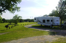
 Note the picnic table and benches - they are made of concrete road construction pieces.

Still on Old Rt 66, I went to Galena – this is getting into
mining country. Although the train had
tracks in the area by 1871 – it wasn’t until they started lead mining that
Galena settled in as a town in 1877 – a rough and tumble kinda town. Originally platted by the Galena Mining and Smelting Company
and was named after the lead ore, galena, found in the area. The city was part of the tri-state mining area and had over 30,000
inhabitants. During World War II,
was a large ordnance plant producing ammonium
nitrate. After the war it was privatized and at one point was the
world's largest producer of ammonium nitrate fertilizer
in the world. After the mines closed in
the 1970s, population decreased.


Must have been a good sale on those clocks......lots of towns in the area have one or more!
After Galena, it was off to Joplin and the rain and the traffic and another round about or two – I would need more than a couple of hours to find my way around Joplin. Then off to Webb City.
After Galena, it was off to Joplin and the rain and the traffic and another round about or two – I would need more than a couple of hours to find my way around Joplin. Then off to Webb City.
Webb City has certainly captured the spirit of Route
66. A mining community, lead was first
discovered in 1873 when John Webb plowed it up while working his fields. In
1876 Webb leased his place to the Center Creek Mining Company and 20 years later
there were over 700 mines within the limits of Webb City and nearby
Carterville. The St Louis and San
Francisco RR came in 1879. There was a
mule street car line from Webb City to Centerville and later, 1893, the South West
Missouri Electric Railway came. During WWI zinc and lead concentrates produced in
the Webb City district were valued at over $18 million. During WWII, explosives were manufactured at
powder plants in the area.


Proud of their mining history, they are in the process of
building a wonderful park to honor that tradition. And, they have taken full advantage of their
location on Route 66 for the tourist trade.

 Another old service station being made into a Chamber of Commerce Tour Info center!


I think the one thing I will remember about Webb City is the
Praying Hands statue 110 tons and 32 feet
tall atop a 40-foot-tall man-made hill. They were sculpted by local artist J.E.
"Jack" Dawson in 1972 – you cannot miss it coming into the
city – it sets high on the hill off the side of the road – gleaming white hands
folded in prayer and a large American Flag.
God Bless America!


From Webb City it was a short jaunt to Carthage and the
Boots Motel for the nite.


No comments:
Post a Comment